** SEVERE ALERT STATUS**

ALERTS | EVENTS | NEWS
 
 
Current Updated News
 
 
Outlooks & Models


* Alert Active For Severe Weather *
SWS Early Warning Monitoring
   
Severe Warning Outlook
MAY - 2013
   
Current Severe Risk
Current Warnings "LIVE NOW" Hazards

ALERT STATUS - SEVERE WEATHER POSSIBLE. Severe weather will be a focus as some approaching systems could display dynamics to align promoting severe activity in the southern Plains region of US. A record low of severe incidents occurred in the March timeframe. The pattern for severe weather pattern is setting up as the Gulf of Mexico is cooler than normal for this time period.

Any severe weather threat can be expected as moisture out of the Gulf of Mexico converges with arriving storms out of the west. Gulf temps are still favorable for severe weather in SPC risk areas. A spring severe pattern is in progress for May. Some northern Conus winter weather can be expected by advancing fronts emerging out of Pacific. Spring winter storms have continued representing May snowfall records in some areas.

PREPARE FOR SEVERE WEATHER EVENTS- GET AN NOAA WEATHER RADIO TODAY. GET IN PREPARATION MODE TODAY. A LINK TO... SEVERE WEATHER CHECKLIST.

Live situations may be posted now on SWS social Network. Use SWS Twitter and Facebook.

(SEE TWITTER AND FACEBOOK LINKS UPDATED NOW)

facebook   Severe Warning Systems is now on Facebook- LIVE NOW
twitter
 
"TWITTER UPDATES" as the weather unfolds- SWS Tweets

Hurricane season officially ended November 30th.

MONITOR IMAGES FOR YOUR LOCATION.. SEVERE WEATHER FOR THIS TIME PERIOD LIKELY.

WEST COAST STORM TRACK - The winter pattern continues showing in the Gulf of Alaska region of the eastern Pacific still active. The coastal activity can be tracked in the Pacific Ocean and therefore coinciding with storm patterns impacting the west coast. Large surf for the pacific west coast will be arriving during the winter pattern. For southwest coast marine conditions- Click Here and Pacific Ocean observations- Click Here


More outlook briefs see Meso Analysis Page. The risk area concentrates on the above noted for possible severe events... This can include high winds.. snow.. and a chance of strong weather conditions.


FOR 
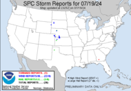
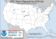
LIVE SPC WARNINGS, OUTLOOKS, MESO DISCUSSIONS & STORM REPORTS - More links and Live Images located below this text for detailed review.

About these alerts... SWS will post alerts as needed for severe weather events.. Team SWS monitors multiple models and recommends using the SPC data below in between SWS alerts.

In any severe warning means that at this time you should make preparations for severe weather events in your area and disaster preparedness to assure protection of lives and personal property... in the event of a severe weather that could impact areas in any alert status.

More SevereWarningSystems.com Live SPC and Mesoscale Long Range Models- Click Here

 
CURRENT OUTLOOK
NEXT DAYS OUTLOOK
Day 1 Convective Outlook
Day 2 Convective Outlook
CURRENT MESO DISCUSSION
CURRENT WARNINGS
Mesoscale Discussions
Watches
TODAYS STORM REPORTS
YESTERDAYS STORM REPORTS
Today's storm reports
Yesterday's storm reports
FOR MORE SevereWarningSystems.com LIVE SPC & LONG RANGE MODELS - Click Here

severe weather, early warning systems


SEVEREWARNINGSYSTEMS .COM

ALL ITEMS ON THIS WEBSITE ARE WRITTEN BY SEVERE WARNING SYSTEMS STAFF. THIS DATA IS ONLY TO BE USED AS PERMITTED BY SEVERE WARNING SYSTEMS. PLEASE REQUEST USE OF THIS MATERIAL BEYOND THE ABOVE NOTED IN OUR TERMS AND CONDITIONS OR BY SWS PERMISSION.

SEVERE WEATHER PREDICTIONS BY "SWS" IS BASED ON MODEL REVIEW AND AN EXPERIENCE OF "SWS" FORECASTING OF SEVERE WEATHER EVENTS. THESE PREDICTIONS ALTHOUGH RELIABLE... ARE NOT GUARANTEED DUE TO THE NATURE OF WEATHER PATTERN CHANGES.

QUESTIONS... FEEDBACK... COMMENTS... USE THE "CONTACT US" LINK ON THIS WEBSITE. © SevereWarningSystems.com

© SevereWarningSystems.com. All Rights Reserved.