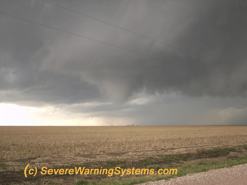
SEVERE WARNING SYSTEMS WILL ATTEND SELECT EVENTS APRIL UNTIL JULY: THIS TIMELINE MARKS THE MOST SIGNIFICANT ACTION FOR TORNADOES AND SEVERE THUNDERSTORMS IN THE MID US. THE SEASON HAS KICKED IN A BIT EARLY AS JANUARY - MARCH HAD SIGNIFICANT TORNADO ACTIVITY IN DIXIE ALLEY AND TEXAS REGION STARTED OFF EARLY IN 2025. AS STRONG LOW PRESSURE SYSTEMS CONTINUE FROM PACIFIC REGION.. ADD THE WARMING GULF OF MEXICO SST's.. AN AREA WE CALL TORNADO ALLEY SHOULD BE PREPARED FOR ROTATING THUNDERSTORMS. Breakthough scientific data was obtained from the 2009 to 2025 tornado seasons. SWS Team volunteers remember the significant data from the "El Reno EF-5" tornado. Over 30 close range tornadic storm epicenter intercepts were achieved with recorded data. Mission accomplished on sufficient field studies and data by the SWS team. Stay tuned to our news page. Close range tornadoes, including a "ground zero" intercept on June 30th 2015 in North Dakota. Multiple tornado events in 2016 include the Katie Ok, Sulfer OK and Atoka tornadoes. May 24 Dodge City KS tornadoes, and a finishing 2016 witnessing the May 25 Chapman tornado from the start in Solomon to Chapman KS. Multiple tornadoes witnessed in 2018 including the Tescott KS EF-3 at close range. Direct intercepts were documented in 2019 and 2020. Over 45 tornadoes were witnessed in spring of 2021, 60+ tornadoes in 2022, 81 tornadoes in 2023, and over 30 so far in 2024 as of mid May. SWS highlight event was April 26th where we witness 15 significant tornadoes. SPC recorded 149 tornado reports. More updates and recent chase log for the Severe Warning Systems team - The SWS News Page |
|---|
SWS RESEARCH PARTICIPANTS FINISHED 2023 WITH MANY CLOSE RANGE TORNADOES. |
 |
NOAA forecasters say that the "El Nino" oceanic situation "is in transition" at this time. This could have a direct impact on how the severe weather pattern will play into this season. Trends of previous year show an above average activity in tornadic storms. Trends may point toward an average tornado season if the Gulf of Mexico shows warming trend with a possible up count for tornadoes. See SWS News as the severe season continues for 2025. |
