Here is a briefing of what we do behind the scenes. Prior to a severe possible event we do analysis of the following. Here are a couple of examples of what we look at. The video is showing what we monitoring in a general sense while in the field. We use GR level 3 for severe thunderstorm live radar when intercepting a storm as wireless card allows. Internet site knowledge is important when wireless cards cannot gain sufficient access.. The severe event noted below... we will outline is from May 22 until May 25th 2008. |
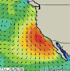
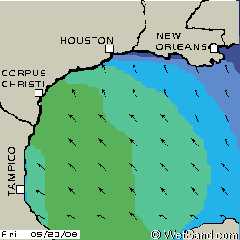
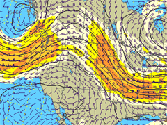
| Oceanic Behavior: We analyze the currents, jet stream, and fetch "wind field" associated with the approaching cold front storm out of the pacific. Next we look at the low level wind out of the Gulf of Mexico. Pictures below show this. |
PACIFIC
OCEAN |
GULF
OF MEXICO |
 |
 |
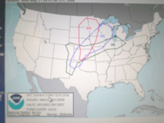
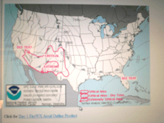
| Storm Prediction Center: We really follow this to verify what the trained meteorologists are predicting. The storm front pressure gradients, as well as their one week prior outlook is observed and taken into account. |
THE
8 DAY OUTLOOK |
THE
FRONTS PRESSURE GRADIENTS |
 |
 |
| Text
Documentation Analysis: Our team studies
all the above and details the data along with all possible meteorologist
text leading up to the severe event. This usually consists of about
50 pages of data we analyze. Upon our review, we then decide if
we need to be on site for the event.
|
| Travel
Planning: If we determine that an event
is going to be a severe outbreak, the next step is taken. Flights
are booked, data for the event is printed out, maps of targeted
area are outlined, and we frequently arrive in Colorado prior to
the possible outbreak event.
|
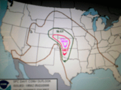
| On Site Upon Arrival: We analyze the latest SPC data the minute we can get the laptop running. The targeted area of severe possibility is mapped out and the travel begins. All Radar links are observed as well as any SPC Public Severe Weather Outlooks, Mesoscale Discussions, and Initial Weather Warnings. |
THE
RISK PROJECTED |
PREDICTED TORNADO OUTLOOK |
 |
 |
| In the Zone: This is where the fun begins. Once we get to the target area, proper placement in a supercell is very important. Radar readings is our key for this as well as SPC analysis of the wind fields, shear, dewpoint, and probable time of rotation. The targeted supercell usually start showing a "hook echo" in our radar readings, this is a sure sign that the cell we are on is tornadic. We use so much data to determine this possibility, it would be too complicated to list all of them. The target is usually on the southwest portion of the supercell. There are instances where we need to be northeast to gather data. It gets pretty dangerous in this area sometimes. We do visually document these events in photos and video, as our goal is to be in early prior to rotation. Our team has achieved this on numerous occasions. |
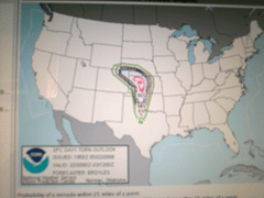
THE
500 MB ISOTACH |
PARTICULARLY DANDEROUS SITUATION WWA |
 |
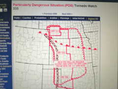 |
| The Particularly Dangerous Situation "PDS": These warnings are the most intense of the weather warnings. This warning means that a serious severe weather event will occur. This day, 5-22-2008, was one to remember as rotating supercells were everywhere. The final tornado count for the day was 48. The red area on the last image shows the area of tornadoes. Amazing chase day in Kansas |
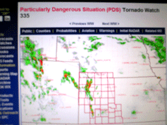
WEATHER WARNING PDS RADAR |
THE
FINAL TORNADO COUNT FOR THIS DAY |
 |
 |
SEVEREWARNINGSYSTEMS .COM - NEWS AND ON-SITE RESEARCH ALL IN A GOOD DAYS WORK: AFTER A SEVERE WEATHER ENTHUSIAST'S DAY LIKE THIS, WE ARE EXHAUSTED BEYOND BELIEF. FORTUNATELY, THE AREA NOTED IN THIS CHASE WAS RELATIVELY CLOSE TO THE AIRPORT OF ARRIVAL (DENVER AIRPORT). THIS DAY DOCUMENTED HERE WAS DAY 1 OF A (4) DAY CHASE. IN THIS OUTBREAK THERE WAS OVER 178 TORNADO REPORTS... FOR THE MONTH OF MAY THERE WAS ALMOST 600... IN THIS CHASE WE WERE BUSY FOR 96 HOURS OF CONTINUED ACTION. WE LOGGED 23OO MILES ON OUR RENTED VEHICLE. IN THE END OF THIS CHASE, WE HAD SO MUCH DATA AND VIDEO TO SORT THROUGH. THERE WAS NOT EVEN A WAY TO COUNT THE AMOUNT OF ROTATION THAT WAS ENCOUNTERED. IN THE COMING MONTHS AHEAD THERE WILL BE A HUGE AMOUNT OF DATA FOR US TO CONTINUE WHAT SEVERE WARNING SYSTEMS IS TRYING TO ACCOMPLISH. |
© SevereWarningSystems.com. All Rights Reserved. |