WELCOME TO SEVEREWARNINGSYSTEMS.COM: SevereWarningSystems.com is a severe weather early warning research organization. We analyze global weather patterns, along with current trends on the outer parameter including ocean currents/temperature, wind fields, and circumstances leading up to a possible severe weather event. Our volunteer team performs detailed analysis on compiled data and the final behavior of these possible severe events. Our pre-event forecast planning has been researching and documenting the powerful phenomena of severe weather since 2001. Specializing in this pre-severe storm planning and being in the field, our core team has behind the scenes and on site experience in predicting a major severe weather event prior to its arrival. SevereWarningSystems is based in Western United States in spring, and the Caribbean in the heart of the Atlantic tropical cyclone machine when it's active.
|
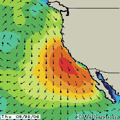
The Pacific Ocean is read to start |
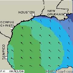
The Gulf of Mexico shows its flow |
 |
 |
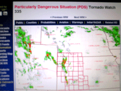
Being in the "zone" |
The results of this day |
 |
 |
The understanding of oceanic behavior coinciding with atmospheric conditions is a key knowledge base for predicting of severe weather outbreaks, possible geographic location, and pinpoint of target arrival. The SWS team has learned much about oceanography and its affect on meteorological events. In observation and further research data on when the big waves would hit the coast, and measured up the size of the storms for being at the right place at the right time. In this detailed analysis, it was then that there was some correlation between when these powerful storms that hit the west coast and a following severe weather event in the mid-section of the U.S. As these "cold fronts" approached, we observed further study the patterns in the Gulf of Mexico. The humidity caused from the warm ocean temperature would be observed as low level wind fields showed a northerly flow. In doing this analysis and compiling hundreds of pages of recorded data, as well as deep studies of the NOAA and SPC meteorology websites. We continue to research "anything" pertaining to mesocyclone activity. At the end of the day, it is "how we can be part of a solution process that minimizes fear", and to further study, participate in research, and contribute to others in our findings moving forward. That is our motive for founding SevereWarningSystems.com. |
LOOKING FORWARD DURING SEVERE WEATHER OUTBREAKS, OUR VOLUNTEERS ARE HARD AT WORK TO GATHER DATA TO BETTER UNDERSTAND THESE EVENTS. SINCE 2007 THERE HAS BEEN INCREDIBLE DATA OBTAINED. CONTINUED RESEARCH HAS CONTINUED WITH SUCCESS TO 2021. FROM THIS POINT ON, SWS PRESENCE FOCUSES ON SELECT SEVERE EVENTS.
|
© SevereWarningSystems.com. All Rights Reserved. |