Below is a brief photo gallery of what we encounter in a chase. These are just a few of what we have. SWS IS ABOUT RESEARCH FIRST... SOLUTIONS... EARLY WARNINGS.. SAVING LIVES... PRESERVATION OF PROPERTY |
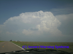
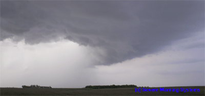
THE SUPERCELL: This is how these storms get going. We look for these monster thunderstorms to produce what we are after. We really like isolated cells as squall line thunderstorms do not produce good "LP" low precipitation. Many squall line storms produce "HP" high precipitation, therefore it is very dangerous an not safe to chase these. |
THE
SUPERCELL |
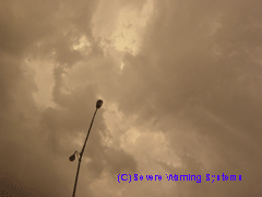
THE
ANVIL |
 |
 |
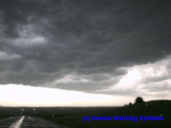
| THE RIGHT POSITIONING: Once you go in to the right spot, it pays off to get in early. If you did your radar analysis right, you get right in under the rotation of the wall cloud. Below are a few examples of what we have experienced timing it right. |
THE
RIGHT PLACE |
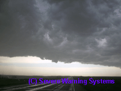
ROTATION
AT ITS BEST |
 |
 |
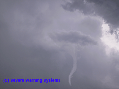
LOW
ROTATING WALL CLOUD |
IN
THE TORNADIC CIRCULATION |
 |
 |
| THE TEXTBOOK HOOK ECHO: Prior to a major tornado event, we got this shot of this cell in a good picturesque rotation. This picture shows a really good view of what we see on radar, but from the ground level. This is an early stage moment. |
 |
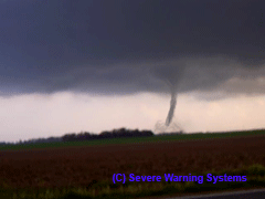
| THE PRIZE: This is what we strive for. To be "in the zone". TORNADOES !!! Getting in early is so rewarding. |
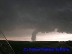
A
GOOD KANSAS WEDGE |
A
REALLY WELL DEFINED TORNADO |
 |
 |
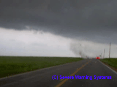
ONE
CROSSES THE ROAD |
TO
CLOSE FOR COMFORT |
 |
 |
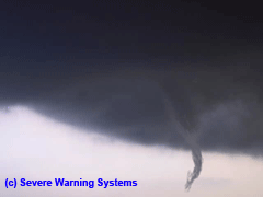
A
GOVE KANSAS ROPE |
A
GOOD PARTIAL IN SOUTH DAKOTA |
 |
 |
A
BEAUTIFUL CONTRAST SD TWISTER |
ANOTHER
FIND IN GOOD OLE KANSAS |
 |
 |
| AT THE END OF A SUCCESSFUL DAY: The below photos were shot at the end of these tornadic storms. There is such a beautiful hue of light as the sun sets and the supercells pick up the lighting. I always look for these types of almost peaceful moments after the storms. |
A
LATE EVENING GUSTNADO |
THE
CALM AFTER THE STORM |
 |
 |
MAMMATUS
CLOUDS |
A
KANSAS SUNSET |
 |
 |
| THE TEXTBOOK CLOUD TO GROUND LIGHTNING STRIKE: We actually had a rotating supercell off the coast in Southern California. A really strong waterspout was sighted out of this cell. This shot wins the prize though. |
 |
WE HAVE SO MUCH IN OUR PHOTO ARCHIVES.. THIS PAGE WILL BE INSANE AFTER WE POST THE NEW PICTURES AFTER THE 2009 SEASON: WE ARE STILL REELING AND PERUSING ON OUR 2008 SEASON. AS IT IS OUR PRIORITY TO STUDY ALL OF OUR VISUAL DATA FOR RESEARCH PURPOSES. AFTER THE MAY SEASON OF 2008, WHERE OVER 595 TORNADO REPORTS ARE DOCUMENTED... IT WAS THE MOST BUSY YEAR FOR TEAM SWS. NOW WE PREPARE FOR THE NEW SPRING SEASON. FIRST AND FOREMOST FOR US AT SEVERE WARNING SYSTEMS, ITS ABOUT RESEARCH. ALL THE PICTURES ARE REALLY SECONDARY FOR US. |
SEVEREWARNINGSYSTEMS .COM - NEWS AND RESEARCH WE HAVE SO MUCH IN OUR PHOTO ARCHIVES: WE ARE STILL REELING AND PERUSING ON OUR 2008 SEASON. AS IT IS OUR PRIORITY TO STUDY ALL OF OUR VISUAL DATA FOR RESEARCH PURPOSES, THERE ARE SOME GREAT PHOTOGENIC SHOTS AS YOU CAN SEE. AFTER THE MAY SEASON OF 2008, WHERE OVER 595 TORNADO REPORTS ARE DOCUMENTED, WE HAVE BETTER PHOTO AND VIDEO GEAR FOR 2009. FOR US AT SEVERE WARNING SYSTEMS, ITS ABOUT RESEARCH. ALL THE PICTURES ARE REALLY SECONDARY. |
© SevereWarningSystems.com. All Rights Reserved. |