2023 SevereWarningSystems.com | Highlight Tornadoes| Tornado Intercepts
2023.. Our Best Tornado Season Since 2011
Our first tornadic storm intercept was January 2nd. Our last tornado documented in 2023 was Oct 4th. This year started off early. We had been watching the La Nina oceanic behavior and the possibility of a very strange weather pattern in the mix. It seemed by climate pattern outlook, this would be an active year for tornadoes.
SWS John and Lloy document near 80 tornadoes to date. 70% of the tornadoes witnessed were brief, rain wrapped, nocturnal, or short lived. SWS Intercept log noted below are "highlight tornado days". There were a lot of significant tornadoes we documented in 2023. * Scroll down for a brief account of SWS pre-season, peak-season, late-season tornado intercepts. |
 |
|
2023 SevereWarningSystems.com | Tornado Intercepts
Pre-Season Tornado Intercepts of 2023
January 2nd.. Mississippi. In analyzing all model data.. John, Lloy and Ryan H head out to Dixie Alley on moderate risk day. This day had potent dynamics for the possibility of strong tornadoes. In our intercept mode, we found a good boundary to play for the second round of storms that were going up to our west. Road network was excellent. The day went to evening, then the 2 dominant storms went warned. We intercepted the tornadic circulation at ground zero. In returning to area south of Ellisville, MS after the storm passed, we noted strong pungent tree debris smell. There was no sighted evidence of tornado debris on ground review. It was nighttime. We called in our findings to the NWS Jackson office for their review.
* Photos and GPS locations documented by crew SWS. Reproduction or use of this content permitted by permission. SWS contents protected by copyright laws. (C)-2023 |
|
 |
|
2023 SevereWarningSystems.com | Tornado Intercepts
Pre-Season Tornado Intercepts of 2023
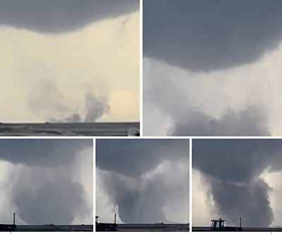
February 26.. Northwest Texas. In analyzing all model data.. John & Lloy head out again for a strong possible day for tornadoes. It is a rare setup this early for the Texas panhandle. Storms took a long time to initiate. As the day turned to evening, storms fired east of Amarillo. Most were messy with rain wrapped circulations. On the outflow boundary, the second round looked promising on the south end. We waited patiently, and the Kelton TX supercell went tornado warned. We were in excellent position to observe the approaching tornado and attemt to gather data inside the circulation. As the lined out storms raced east raced east, we counted our day to the Kelton intercept successful. Once storms hit east, a rain wrapped tornado rated EF-2 hit Norman OK. John and Lloy did damage survey documentation in Norman.
* Photos and GPS locations documented by crew SWS. Reproduction or use of this content permitted by permission. SWS contents protected by copyright laws. (C)-2023 |
|

|
|
2023 SevereWarningSystems.com | Tornado Intercepts
Pre-Season Tornado Intercepts of 2023
March 2nd.. Northeast Texas. In analyzing all model data.. John, Lloy and Ryan H head out again for a strong possible day for tornadoes. A possibly reasonable tornado day looks to be setting up in Northeast Texas. Early tornadic storms were moving northeast from southern Texas and Louisiana. We held or ground west of Texarkana. As the day turned to evening, storms fired south of our location. Storms were isolated and producing tornadoes to our south and east. We went in to intercept a tornado observed storm coming in to us from the south as we experienced a freeway speed tire blowout. The tornado lifted, and storm just dissapated. We were in position after tire change to get the Oklahoma Texas border storm west of Texarkana for intercept. We stayed south of the occlusion to see the tornado perfectly plant along side of us in rural area.
* Photos and GPS locations documented by crew SWS. Reproduction or use of this content permitted by permission. SWS contents protected by copyright laws. (C)-2023 |
|
 |
|
2023 SevereWarningSystems.com | Tornado Intercepts
Pre-Season Tornado Intercepts of 2023
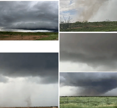
March 31st.. High Risk Day. Iowa Illinois In analyzing all model data.. John prepares for a fly-in to Des Moines Iowa. A bi-modal high risk day, possibly outbreak for tornadoes day looks to be setting up in Eastern Iowa. Early tornadic storms were moving northeast from Missouri and northern Nebraska. We stayed put in east Iowa for the forward initial storms firing in western Illinois. We intercepted a tornadic storm that produces a brief photogenic tornado. Looking west we see the east Iowa storm going haywire. we blast west to the high speed supercells heading towards us. We see reports of a possible wedge on the ground near Ottowa IA. We missed it. in direct intercept position of any supercells in this line we hold east of the strongest supercell. and the Geneseo violent tornado births heading right towards us. Storm speeds at over 70 mph made this intercept intense. We executed timely and safely. As that EF-2 lifted, another stovepipe tornado sighted on the ground to east. Second tornado also rated EF-2. We stayed ahead of line after dark to witness another tornado near Juliet IL. We witnessed 4 tornadoes this day.
* Photos and GPS locations documented by crew SWS. Reproduction or use of this content permitted by permission. SWS contents protected by copyright laws. (C)-2023 |
|

|
|
2023 SevereWarningSystems.com | Tornado Intercepts
Pre-Season Tornado Intercepts of 2023
April 4th.. Central Iowa. Another Bi-Modal moderate/high risk day relative to the March 31st setup. Just as favorable for a possible significant tornado outbreak. John, Lloy and Ryan H head out again for a strong possible day for tornadoes. A possibly reasonable tornado day looks to be setting up in central Iowa. Early tornadic storms were moving northeast from Nebraska into southern Iowa. We set up initial base south of Des Moines and patiently awaited the boundary moving towards us. As storms started to fire in southwest Iowa, we decided to drop in for a closer look. Storm goes tornado warned as we are on excellent intecept path. getting in circulation, John observes tornado spin up 50 feet away while on foot. Staying with storm after large hail we observe the beauty of tornadoes near Lacona IA. Intercepted another tornado past sunset west of Newton IA We witnessed 4-5 tornadoes this event.
* Photos and GPS locations documented by crew SWS. Reproduction or use of this content permitted by permission. SWS contents protected by copyright laws. (C)-2023 |
|

|
|
2023 SevereWarningSystems.com | Tornado Intercepts
Early Season 2 Day Tornado Intercept
April 25 to 26.. Northeast Texas Into Lousiana. A messy setup yields us a few brief tornado encounters. Both days we ran hard to stay in intercept position. Early tornadic storms were moving northeast from southern Texas and Louisiana. We staged near northeast of Waco Texas. The day was showing forward storms west of Shreveport LA and some storms east of Austin TX we could not catch. We blasted hard do the storm heading notheast fo Tyler TX. A lot of work, we got a brief spin up west of LA border. As the day turned to evening, storms fired south of our location. Storms were isolated and producing tornadoes to our south and east. The other nighttime possible tornadoes were captured at night. Plenty of lightning luminated the occlusions to see action in great view. These two days were amazing, but unphotogenic for the amount of mesocyclone activity we got on video to verify the 4-5 brief tornadoes we documented.
* Photos and GPS locations documented by crew SWS. Reproduction or use of this content permitted by permission. SWS contents protected by copyright laws. (C)-2023 |
|
|
2023 SevereWarningSystems.com | Highlight Tornadoes| Significant Tornado Intercepts
April 28th and into early May
A few brief tornadoes were observed in this time period. April 28th.. north of Kileen TX significant rain wapped tornado occured that we documented. Then May 4th.. south of Crowell TX. Stong circulation occurred with multi vortice brief spinups. May 5th.. near Marble Falls TX.. A brief large circulation was observed making ground contact we documented under the occlusion. May 6th.. We intercept a tornadic supercell heading towards Brownwood TX., we stay in the bears cage on this long tracked storm to south of Zephyr and Oklahoma border.. May 7th.. we hedged our bets and went to Iowa. The supercell we intercepted exibited rotation with funnels. This storm did not produce a tornado. May 9th..We get a couple brief tornadoes near Nebraska Kansas border..Most of the tornadoes we witnessed in this timeline were brief, rain wrapped, noctornal, or short lived. Now moving intto peak tornado season.
* * * * SCROLL DOWN FOR THE 2023 TORNADO SEASON RAMPS UP BIG TIME * * * * |
|
|

|
|
2023 SevereWarningSystems.com | Tornado Intercepts
Peak Season Tornado Intercepts of 2023
May 10th.. Northeast Colorado. An active period for tornadoes was forecast by long range into short range time period. John and Lloy planned for a long duration of travel. We left Southern California packed for this possibility of multi day tornado events. Heading north of Limon CO.. we witnessed a long period landspout tornado with a double landspout near Woodrow CO. We headed north and positioned between 2 tornado warned supercells. Between 2 occlusions we capured tornadoes close range of the left of us and the right.. almost simataneously. We witnessed and documented 4-5 tornadoes this day.
* Photos and GPS locations documented by crew SWS. Reproduction or use of this content permitted by permission. SWS contents protected by copyright laws. (C)-2023 |
|
 |
|
2023 SevereWarningSystems.com | Tornado Intercepts
Peak Season Tornado Intercepts of 2023
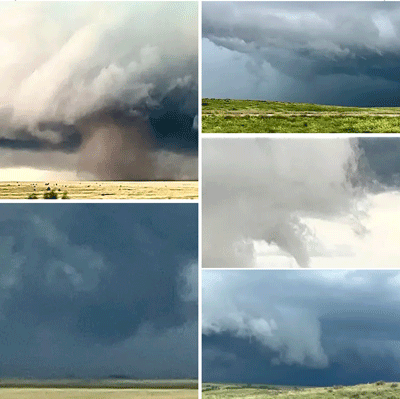
May 11th.. Northeast Colorado to Northwest Kansas. This day, we played the cold core setup near Cheyenne Wells CO. SPC had the severe risk in Oklahoma to north Texas. John and Lloy decided that if the cold core setup could materialize, the possibility of tornadoes would be cyclical. Sitting on the outside area near Sharon Springs Kansas, we noticed the cold core arc blowing up convectively north of Los Animas CO.. we headed in to the arcing development of storms. IAn occlusion with stovepipe tornado drops about 6 miles south heading our direction. We had 2 detailed stovepipe tornadoes on the ground, and the 3 cold core tornadic supercells kept dropping tornadoes all the way to almost Rexford Kansas before tornadic activity subsided. We witnessed and documented 8-9 tornadoes this day. The high contrast detail, with entire tornado cycles made this day special.
* Photos and GPS locations documented by crew SWS. Reproduction or use of this content permitted by permission. SWS contents protected by copyright laws. (C)-2023 |
|
 |
|
2023 SevereWarningSystems.com | Tornado Intercepts
Peak Season Tornado Intercepts of 2023
May 12th.. Eastern Nebraska. Another Cold core setup appears likely. First tornadic supercell produces a wedge near Spaulding NE. We decided not to run for it. We were behind for first tornadic storm. As the arcing natire of the cold core progressed, there was multiple tornadic storms. We intercepted a stovepipe tornado near Petersburg. After tornado lifted we proceeded east. Within a half mile farmstead was hit. twisted powerpoles and trees, building debris and farm equipment strewn in a 1/4 mile radius, we call the damage in to emergency responders. The next tornado formed close range south of Stanton NE. We witnessed and documented 2 more tornadoes near the Nebraska Iowa border. This moderate risk day John and Lloy documented 4 tornadoes.
* Photos and GPS locations documented by crew SWS. Reproduction or use of this content permitted by permission. SWS contents protected by copyright laws. (C)-2023 |
|
 |
|
2023 SevereWarningSystems.com | Tornado Intercepts
Peak Season Tornado Intercepts of 2023
May 13th.. Central Iowa. This day was filled with so many tornado warned storms. It was an unexpected treat. All within a 50 mile radius for over 5 hours. The tornadic storms all trained near Pleasantville to Knoxville IA. Most of the tornadoes were brief, weak and photogenic. The day was filled with every storm going into rotation and short, brief tornado producers. Late in the day, we went to Monroe IA about 30 miles north for dinner. Thinking the day was done.. Not. By the time we finished up with food, another supercell popped up and went tornado warned. Back down across Lake Red Rock again, and into another tornado producer. We crossed that lake, back and forth, all around four times. Only 23 miles from our dinner spot. More tornado touchdowns. We documented 8-9 close range weak tornadoes. The structure and storms moving 3-5 knots max made for a very enjoyable intercept day. We went into the vault region of 14 different tornado warned storms within the area. Super enjoyable day.
* Photos and GPS locations documented by crew SWS. Reproduction or use of this content permitted by permission. SWS contents protected by copyright laws. (C)-2023 |
|
Late May into June | Supercell Intercepts Continue | Southern Plains Gets Severe Storms Late
This time period was hit and miss for any tornadoes. It seemed like the northern plains just shut down this year because of the high pressure ridge holding in position for weeks. We spent the next weeks in Texas and New Mexico. Day after day of severe weather events . The season continues with some breaks between severe weather events. |
 |
|
2023 SevereWarningSystems.com | Tornado Intercepts
Peak Season Tornado Intercepts of 2023
May 18th.. Texas Panhandle. A big high pressure dome heats up the central and northern plains. a southern subtropical jet feeds moisture into the southern plains creating a late and consistent severe weather events day after day in Texas Panhandle and New Mexico. The structure was absolutely stunning. A few good tornadic supercells struggled to produce tornadoes. We documented a few brief tornadoes this day. The finaly was the direct circulation intercept north of Panhandle after dark. Documenting the tornadic wind switch directions and a bunch of Texas tumbleweeds getting spun into front of us. We were surprised the strong mesocyclone did not produce a big tornado. A great spot on intercept regardless.
* Photos and GPS locations documented by crew SWS. Reproduction or use of this content permitted by permission. SWS contents protected by copyright laws. (C)-2023 |
|
 |
|
2023 SevereWarningSystems.com | Tornado Intercepts
Peak Season Tornado Intercepts of 2023
June 1.. West Central Texas. The southern subtropical jet feeds moisture in to southern plains creating a late and consistent severe weather events day after day in Texas Panhandle and New Mexico. This days structure was absolutely stunning. A few decent supercells struggled to produce tornadoes. We documented a few brief tornadoes this day. John and Lloy attend this severe weather event with Tim Marshall and Russ Contreras. Some of our favorite crew from Texas. We intercepted in great position all day. Once the storms began to show elevated bases, Tim always find the best Mexican restaraunts anywhere in the country. We end up meeting with multiple people and go over the days captures and next days planning. The topic.. Where are these long tracked photogenic tornadoes?
* Photos and GPS locations documented by crew SWS. Reproduction or use of this content permitted by permission. SWS contents protected by copyright laws. (C)-2023 |
|
 |
|
2023 SevereWarningSystems.com | Tornado Intercepts
Peak Season Tornado Intercepts of 2023
June 2nd.. Eastern New Mexico into west Texas. The southern subtropical jet continues feeding moisture into southern plains creating more severe weather events day after day in Texas and New Mexico. This days structure was absolutely colorful and stunning. A few decent supercells ramped up and produced brief rain wrapped tornadoes. For the most part.. high precipitation supercells created iffy photogenic opportunities. We documented a few brief close range tornadoes this day. Severe weather keeps showing up in New Mexico late this year. We intercepted in great position all day. We end up all the way near Odessa TX when its all said and done. Well.. where is our long track tornadoes?
* Photos and GPS locations documented by crew SWS. Reproduction or use of this content permitted by permission. SWS contents protected by copyright laws. (C)-2023 |
|
 |
|
2023 SevereWarningSystems.com | Tornado Intercepts
Peak Season Tornado Intercepts of 2023
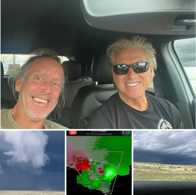
June 11th.. Eastern New Mexico into west Texas. Dallas and John get into our annual intercept mode for day one. The southern subtropical jet continues feeding moisture into southern plains creating more severe weather events day after day in Texas and New Mexico. We meet up with Tempest Tour crew in eastern New Mexico. The terrain and road network gets tricky on intercept mode making close range difficult. We did document a brief tornado north of Branson in southern Colorado. We end the day in Clayton New Mexico. Then we plan for the following day in deep Texas territory. A solid 6 hour drive to target near Brady TX.
* Photos and GPS locations documented by crew SWS. Reproduction or use of this content permitted by permission. SWS contents protected by copyright laws. (C)-2023 |
|
 |
|
2023 SevereWarningSystems.com | Tornado Intercepts
Peak Season Tornado Intercepts of 2023
June 12th.. Brady Texas. The southern subtropical jet continues feeding moisture into deep southern plains creating more severe weather events day after day in Texas. This days structure was absolutely stunning. A dominant supercell ramped up north of Melvin Texas. Dallas and I meet up with Reed Timmer, Russ Contreras, We intercepted in great position all day. The mega supercell was almost 60,000 feet in height. We got in super close to circulation. The amount of storm enthusiasts out made the roads crowded and dangerous. We document a brief spinup near Brady TX. We call the day and plan for the next days events. Dallas decided to sit the next day out due to distance and amount of storm chaser convergence. John plans roads to next days possible target. A grueler morning drive to northern Texas panhandle was in store to capture possible tornadoes.
* Photos and GPS locations documented by crew SWS. Reproduction or use of this content permitted by permission. SWS contents protected by copyright laws. (C)-2023 |
|
 |
|
2023 SevereWarningSystems.com | Tornado Intercepts
Peak Season Tornado Intercepts of 2023
June 13th.. Oklahoma Panhandle south of Boise City. The morning drive from Brady Texas was a tough one. No time for anything but the driving grind. I ride solo to target. With zero time to spare.. I enter the severe warned supercell by Boise City as it goes tornado warned. Within 30 minutes, 2 close range tornadoes were documented. The road along the panhandle border made this intercept amazing in the early stages of storm evolution. The storm started going high precipitation.. but still had strong rotaion. I met up briefly with Tim Marshall, Doug and Carrie Cunningham. This supercell had a 4 inch hail core as it raced due south. Tim wanted to document the hail. We said "hail no" and stayed ahead of the complex blasting south. We did our best to stay ahead of it until the transition to outflow dominant at high speed was apparent.
* Photos and GPS locations documented by crew SWS. Reproduction or use of this content permitted by permission. SWS contents protected by copyright laws. (C)-2023 |
|
 |
|
2023 SevereWarningSystems.com | Tornado Intercepts
Peak Season Tornado Intercepts of 2023
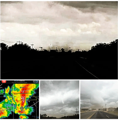
June 15th.. Texas Panhandle Higgins TX The day looked to be the forward storms moving into Oklahoma. We played initial target in between the forward storms and the approaching linear storms. It was apparent that if we went for forward storms, which we may not catch, We would be out of play for back semi-discrete line. Getting late, we decided to head west. The storms started going semi discrete, with strong meso markers, A strong tornado hit Perryton TX rated EF-3. We were close, but decided to play the next in line. I was with Tim Marshall, Doug and Carrie Cunningham on this run. We worked hard to get in range without getting the large hail, as the road veered east and the beast of a tornado dropped to our right. A decisive move to abort the eastern supercells for a line event. That was hard. We were granted a fine reward. This large photogenic tornado was incredible to watch. A damage survey was done in Perryton TX prior to the next days severe events.
* Photos and GPS locations documented by crew SWS. Reproduction or use of this content permitted by permission. SWS contents protected by copyright laws. (C)-2023 |
|
June - July | Supercell Intercepts Continue | Central Plains Continues Getting Severe Storms
June 16th and 17th.. Oklahoma Panhandle Both days were great from the intercept position. Both the 16th and 17th were reasonable severe weather days. A lot of photos and video to sort through of these days. The season continues. The next intercepts will be late severe weather events. There was plenty to be had. 2023, the year that kept giving. |
 |
|
2023 SevereWarningSystems.com | Tornado Intercepts
Late Season Tornado Intercepts of 2023
June 28.. Kimball NE. This day was an incredible from the start. Running with Tim Marshall this event. This day materialized into an epic tornado day. The early stages of the supercell had that look of surface based from the initial stages. The storm cycled a bit, then the VIL went tight and strong. The tornado warned beast produced a good tornado. As the tornado moved east, we Paralleled its track and intercepted it direct. Incredible data was recorded inside the circulation. We continued to track this tornadic supercell until it finally went outflow dominant. Timelapse video, More details of this intercept will be ongoing for years ahead. We actually watched this tornado start, hit a manure pile, and that detailed the circulation as it got stronger.
* Photos and GPS locations documented by crew SWS. Reproduction or use of this content permitted by permission. SWS contents protected by copyright laws. (C)-2023 |
|
 |
|
2023 SevereWarningSystems.com | Tornado Intercepts
Late Season Tornado Intercepts of 2023
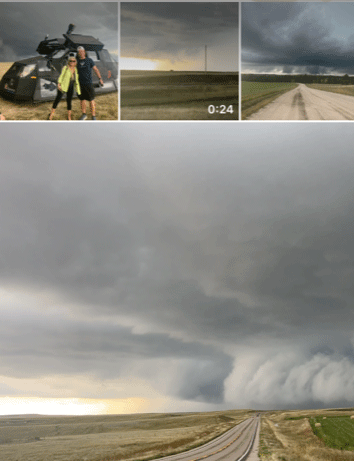
June 30th.. Eastern Colorado This day was interesting. Heading south ot of Limon towards Hugo. As we were granted a fine reward of a couple supercells. This photogenic supercell was incredible to observe. An early QLCS type possible tornado occurred in plain view. Early on this storm near Flagler CO put out brief incredible multi-vortice tornado. The day ended in a place we have been looking for a supercell basecamp.. Sharon Springs Kansas. The rest of the late tornado season was centered on the area for practical use intercepting supercell storms. The season kept showing good supercell potential, we stayed in the area.
* Photos and GPS locations documented by crew SWS. Reproduction or use of this content permitted by permission. SWS contents protected by copyright laws. (C)-2023 |
|
July - October | Supercell Intercepts Continue | Central Plains Continues Getting Severe Storms
Late season in Eastern Colorado.. The subtropical jet continues to keep the season active. We find a possible basecamp for severe weather seasons moving ahead. With this opportunity, we get to test the area with arriving severe events. Models show the possibilities in the mid range looking great. July 4 - 7 were good supercell intercept days. Still sorting through video and photos.. The Kim Colorado long track tornadic supercell road network for intercept was exceptional. |
 |
|
2023 SevereWarningSystems.com | Tornado Intercepts
Late Season Tornado Intercepts of 2023
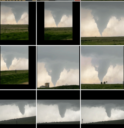
July 8th.. Kim Colorado A day well played. The models showed the most incredible helicity track an almost every near event run. Oh yes.. it verified. Over 125 miles of the tornadic icemaker with structure from a different planet. The road network was near perfect to stay in the vault region of supercell. The timelapse opportunities, the lighting with structure was incredible for hours. The tornado was beautiful, although the phases of cycling of this huge mesocyclone dominated the tornado.
* Photos and GPS locations documented by crew SWS. Reproduction or use of this content permitted by permission. SWS contents protected by copyright laws. (C)-2023 |
|
 |
|
2023 SevereWarningSystems.com | Tornado Intercepts
Late Season Tornado Intercepts of 2023
August 5th.. Eastern Colorado This day was unexpected. We were working at the supercell basecamp in northwest Kansas. Storms were showing out of the Palmer divide in northeast Colorado around noon. The Colorado Springs storm went tornado warned. We just left the basecamp heading west toward Cheyenne Wells CO. We had 100 miles to intercept position. John and Lloy looked at situation and didnt think we would get anything. . Heading south towards Limon we can see that we made it to see tornadoes. Once we got to a southbound out of Limon, we had unobstructed view of the base and wall cloud continuing toward Ordway CO we witness 2 more brief touchdowns. The unexpected day gave us a few photegenic tornadoes from a distance. We documented 3 tornadoes on this day.
* Photos and GPS locations documented by crew SWS. Reproduction or use of this content permitted by permission. SWS contents protected by copyright laws. (C)-2023 |
|
 |
|
2023 SevereWarningSystems.com | Tornado Intercepts
Late Season Tornado Intercepts of 2023
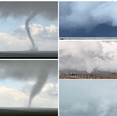
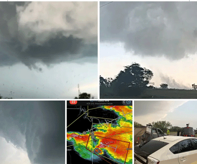
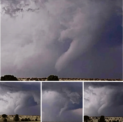
August 8th.. Eastern Colorado This day was absolutely wild. On our way back to SoCal we decided to detour a bit up northwest into northeast Colorado. We saw towers going up near Sterling CO. We headed towards Otis-Yuma direction. As we approched the supercell, it goes tornado warned. Driving right up to a forming multi vortice wedge tornado This slow moving beast was captured in detailed timelapse until it weakened. A weak stovepipe formed on left as wedge occluded, within 2 minutes this tornado dissapated. Tornado number 3.. a photogenic tornado was on the ground for 25 minutes 50 meters from us barely moving. We captured incredible video and timelapse of this stovepipe tornado before sampling this tornado at zero meter range. This tornado rated EF-3. As this tornado lifted we stayed in notch position of this storm past Kirk CO. 3 more tornadoes witnessed near Joes and Kirk, including an anticyclonic close range intercept. On the way south we observed a lightning lit stovepipe tornado west of Kit Carson CO from a newly formed supercell.
* Photos and GPS locations documented by crew SWS. Reproduction or use of this content permitted by permission. SWS contents protected by copyright laws. (C)-2023 |
|
 |
|
2023 SevereWarningSystems.com | Tornado Intercepts
Late Season Tornado Intercepts of 2023
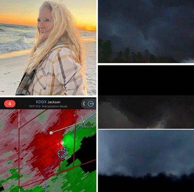
August 20.. Southern California Intercepting a Tropical Storm in the heart of SoCal? Yes indeed. Hurricane Hilary headed right into San Diego territory as a tropical storm. This day was interesting. We headed east from south Orange County base at 2:30am. Our timing plan was to get in early position on the northeast quadrant of approaching Tropical Storm Hilary. We were early, took a good snooze outside of Indio and gauged radar for the iphone alarm wake up alarm. An early outer band low topped supercells showed up on radar, we headed in for a better look. We observed a pretty good size HP tornado close range in Mecca CA. This tornado was fast moving, pretty epic to watch track accross Interstate 10 west of Desert Center. One other storm observer shared photos on social media from Desert Center. It had the appearance of a cone tornado from their vantage point. We continued to flood zone to document the rain deluge.
* Photos and GPS locations documented by crew SWS. Reproduction or use of this content permitted by permission. SWS contents protected by copyright laws. (C)-2023 |
|
|
|
2023 SevereWarningSystems.com | Tornado Intercepts
Late Season Tornado Intercepts of 2023
Sept 22.. Eastern Wyoming into Western Nebraska This day had potential. On our way back to supercell basecamp in Northwest Kansas, we decided to take the northern route east into Wyoming. We saw towers going up near Douglas WY as we were in position west of Casper WY. We headed towards Lusk WY to be in notch position of the storm we decided to stick with. As we approched the supercell, the wall cloud started rotating rapidly and looks to be producing a possible tornado west of Van Tassel WY. We captured incredible video and timelapse of this possible tornado or ground scrubbing rapid rotating wall cloud. Then continued with this dominant supercell in its cycling mode from Lusk WY to Crawford NE. We had epic road network to view many cycles of this supercell right on the edge of hail core. From west of Harrison NE, this long tracking supercell started to show outflow dominant trends. and would recycle into a strong rotating wall cloud. Hours of great road network made this day worth the trip.
* Photos and GPS locations documented by crew SWS. Reproduction or use of this content permitted by permission. SWS contents protected by copyright laws. (C)-2023 |
|
 |
|
2023 SevereWarningSystems.com | Tornado Intercepts
Peak Season Tornado Intercepts of 2023
Oct 4th.. Texas Panhandle This day was interesting. An early day of racing high base supercells with multiple hail cores made a tough decisive process. We liked the boundary by Paducah TX. Supercells were going into good rotation from the lubbock area early. We stuck to that boundary and it played excellent. Beautiful structure, strong mesocyclone behavior out of each intercepted supercell documented. The dominant supercell at the back of line was approaching our area. We raced south out of Paducah southbound toward Guthrie. About 1/2 mile away, a landspout cylinder is on the ground. Lloy and I hurry to document this as we were working to stay out of hail core. The unexpected sighting caught us both off guard. We proceed east and south as the whole complex goes outflow dominant. This is our last severe weather intercept to date.
* Photos and GPS locations documented by crew SWS. Reproduction or use of this content permitted by permission. SWS contents protected by copyright laws. (C)-2023 |
|
|
SEVEREWARNINGSYSTEMS .COM - 2023 Tornado intercept Log
ALL INTERCEPTS ARE DOCUMENTED BY SEVERE WARNING SYSTEMS.. JOHN HALLEN & LLOY BAUMEISTER.
WEBSITE AND TORNADO INTERCEPT PAGE CONTENT AUTHORED BY JOHN HALLEN (C ) - 2023 |
|
|