ABOUT THUNDERSTORMS - A SEVERE WARNING SYSTEMS EXCLUSIVE
|
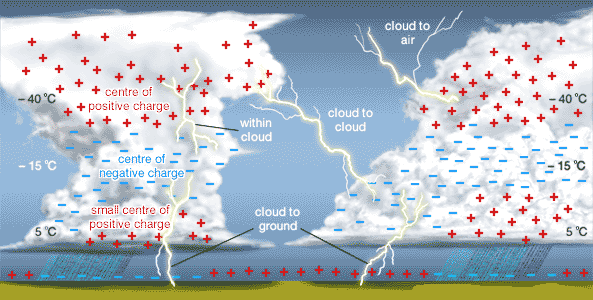
How does a thunderstorm form? Three basic ingredients are required for a thunderstorm to form: moisture, rising unstable air (air that keeps rising when given a nudge), and a lifting mechanism to provide the "nudge." The sun heats the surface of the earth, which warms the air above it. If this warm surface air is forced to rise -- hills or mountains, or areas where warm/cold or wet/dry air bump together can cause rising motion -- it will continue to rise as long as it weighs less and stays warmer than the air around it. As the air rises, it transfers heat from the surface of the earth to the upper levels of the atmosphere (the process of convection). The water vapor it contains begins to cool, releasing the heat, and it condenses into a cloud. The cloud eventually grows upward into areas where the temperature is below freezing. Some of the water vapor turns to ice and some of it turns into water droplets. Both have electrical charges. Ice particles usually have positive charges, and rain droplets usually have negative charges. When the charges build up enough, they are discharged in a bolt of lightning, which causes the sound waves we hear as thunder. Below is an illustration of electrical properties and temperatures inside a thunderstorm. |
 |
|
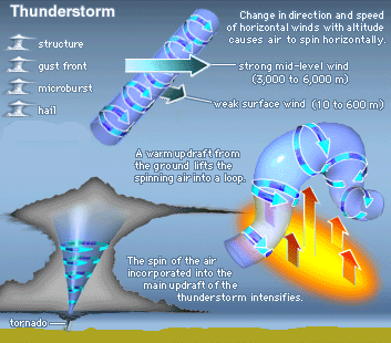
Thunderstorm facts Lightning occurs with all thunderstorms and is very dangerous. Most lightning strikes are cloud to cloud but some are cloud to ground (pictured above) and these are the ones which kill about 93 people/year in the U.S. Lightning is caused by the action of rising and descending air within a thunderstorm that separates positive and negative charges. Water and ice particles in the thunderstorm also affect the distribution of electrical charge. Lightning results from the buildup and discharge of electrical energy between positively and negatively charged areas. The average lightning strike has enough energy to light a 100 watt bulb for 3 months. The air near a lightning strike is heated to near 50,000 F, hotter than the surface of the sun. The rapid heating and cooling of the air near the lightning channel causes a shock/sound wave that results in thunder. Most lightning deaths and injuries occur when people are caught outdoors. Thunderstorms produce other hazards as well. The number 1 thunderstorm killer is flash flooding. Flash flooding from thunderstorms kills about 140 people/year in the U.S.. Another hazard from thunderstorms is large hail. Large hail is generally 1 inch in diameter or larger and can cause a great deal of damage. Hail damage in the U.S. averages about $1 billion per year. Large hailstones can fall at speeds faster than 100 mph. Straight line winds are responsible for most thunderstorm wind damage. On land, wind gusts from thunderstorms usually need to be greater than 50 mph to cause damage, however, over water, wind gusts of 30 mph (26 knots) or greater can be dangerous to small boats. One type of straight line wind, a downburst, can cause damage similar to tornadoes and is extremely dangerous to aviation take offs and landings. A downburst is a small area of rapidly descending air beneath a thunderstorm. This air can cause damaging winds in excess of 100 mph. Downbursts are associated with severe thunderstorms and not all thunderstorms produce downbursts. Tornadoes are the most dangerous and damaging aspect of severe thunderstorms. Wind speeds of tornadoes can reach to near 300 mph and cause an average of 80 deaths and 1,500 injuries per year in the U.S. Most fatalities from tornadoes occur in mobile homes and in automobiles. Below is an illustration of a tornadic thunderstorm. |
 |
|
Types of thunderstorms THE SINGLE CELL STORM: Single cell thunderstorms usually last between 20-30 minutes. A true single cell storm is actually quite rare because often the gust front of one cell triggers the growth of another. Most single cell storms are not usually severe. However, it is possible for a single cell storm to produce a brief severe weather event. When this happens, it is called a pulse severe storm. Their updrafts and downdrafts are slightly stronger, and typically produce hail that barely reaches severe limits and/or brief microbursts (a strong downdraft of air that hits the ground and spreads out). Brief heavy rainfall and occasionally a weak tornado are possible. Though pulse severe storms tend to form in more unstable environments than a non-severe single cell storm, they are usually poorly organized and seem to occur at random times and locations, making them difficult to forecast. THE MULTICELL CLUSTER STORM: The multicell cluster is the most common type of thunderstorm. The multicell cluster consists of a group of cells, moving along as one unit, with each cell in a different phase of the thunderstorm life cycle. Mature cells are usually found at the center of the cluster with dissipating cells at the downwind edge of the cluster. Multicell Cluster storms can produce moderate size hail, flash floods and weak tornadoes. Each cell in a multicell cluster lasts only about 20 minutes; the multicell cluster itself may persist for several hours. This type of storm is usually more intense than a single cell storm, but is much weaker than a supercell storm. THE MULTICELL LINE STORM (SQUALL LINE): The multicell line storm, or squall line, consists of a long line of storms with a continuous well-developed gust front at the leading edge of the line. The line of storms can be solid, or there can be gaps and breaks in the line. Squall lines can produce hail up to golf-ball size, heavy rainfall, and weak tornadoes, but they are best known as the producers of strong downdrafts. Occasionally, a strong downburst will accelerate a portion of the squall line ahead of the rest of the line. This produces what is called a bow echo. Bow echoes can develop with isolated cells as well as squall lines. Bow echoes are easily detected on radar but are difficult to observe visually. THE SUPERCELL STORM: The supercell is a highly organized thunderstorm. Supercells are rare, but pose a high threat to life and property. A supercell is similar to the single-cell storm because they both have one main updraft. The difference in the updraft of a supercell is that the updraft is extremely strong, reaching estimated speeds of 150-175 miles per hour. The main characteristic which sets the supercell apart from the other thunderstorm types is the presence of rotation. The rotating updraft of a supercell (called a mesocyclone when visible on radar) helps the supercell to produce extreme severe weather events, such as giant hail (more than 2 inches in diameter), strong downbursts of 80 miles an hour or more, and strong to violent tornadoes. The surrounding environment is a big factor in the organization of a supercell. Winds are coming from different directions to cause the rotation. And, as precipitation is produced in the updraft, the strong upper-level winds blow the precipitation downwind. Hardly any precipitation falls back down through the updraft, so the storm can survive for long periods of time. The leading edge of the precipitation from a supercell is usually light rain. Heavier rain falls closer to the updraft with torrential rain and/or large hail immediately north and east of the main updraft. The area near the main updraft (typically towards the rear of the storm) is the preferred area for severe weather formation. |
ALL NEWS ITEMS ARE WRITTEN BY SEVERE WARNING SYSTEMS STAFF. THIS DATA IS ONLY TO BE USED AS PERMITTED BY SEVERE WARNING SYSTEMS. PLEASE CONTACT US BY CLICKING ON THE LINK "CONTACT US".